|

|
||||||||||||||||||||||||||||||||||||||||||||||||||||||||||||||||||||||||||||||||||
| Five longest rivers in Japan | ||
| Ranking | Name of the river | Length(km) |
| 1 | The Shinano | 367 |
| 2 | The Tone | 322 |
| 3 | The Ishikari | 268 |
| 4 | The Teshio | 256 |
| 5 | The Kitakami | 249 |
| Five widest areas of the river basin | ||
| Ranking | Name of the river | Area(km2) |
| 1 | The Tone | 16,840 |
| 2 | The Ishikari | 14,330 |
| 3 | The Shinano | 11,900 |
| 4 | The Kitakami | 10,150 |
| 5 | The Kiso | 9,100 |
The number of river branches of the Shinano River is second in Japan. Each river branch gives all kinds of benefits to people living in the river basin.
| Top 5 ranking number of river branches in Japan | ||
| Ranking | Name of the river | Number of river branches |
| 1 | The Yodo | 962 |
| 2 | The Shinano | 880 |
| 3 | The Tone | 805 |
| 4 | The Fuji | 555 |
| 5 | The Tsukihiro | 475 |
Since 70% of Japan is mountainous, water flows nonstop from the source of a river, in the mountains to the sea. The incline of the rivers are steep, so water flows fast.
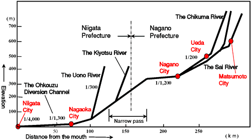
Extension and inclination of the Shinano River
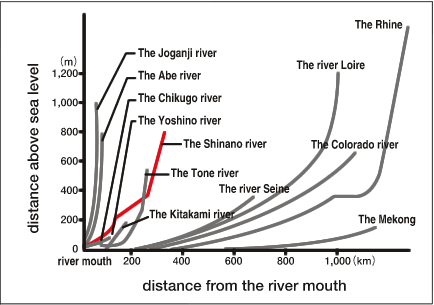
Inclines of rivers