| Complex and Brittle Geological Features Caused by Uplift, Great Fault,
and Volcanic Activities |
The Hida mountain range commonly known as the gNorth Alpsh with the tall
and sharp rocks, crests, and snow patches stretching all the way deserves
exactly the name of the gAlpsh given to it in appearance. From the geological
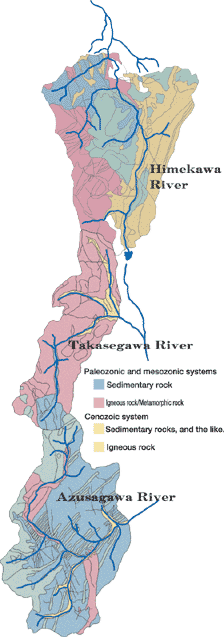
viewpoint, the granite and the porphyrite that are the igneous rocks penetrate
the sedimentary rock that was created during the palaeozonic era, which
is in part covered with the ejecta from a volcano. The beautiful ridges
were made by gradual weathering of a group of its isolated mountains through
the action of volcanic activities added after the fierce uplifting movements
during the palaeozonic era and the mountain-making movements of the great
fault. The North Alps is still undergoing an uplift although it is not
noticeable. In the meanwhile, the brittle soil such as the weathered sedimentary
rock and metamorphic rock is collapsed into earth and sand, and continues
to be transported downstream. Besides, Yakedake that is the only active
volcano in the North Alps grows through the volcanic activities, and is,
so to speak, a mountain made through the accumulation of lava flow, pyroclastic
flow, and debris flow. Therefore, you have to be on alert for the brittle
and collapsible ground at all times.
|
|
 |
| Fossa Magna and Itoigawa-Shizuoka Tectonic Line |
 |
|
Fossa Magna refers to the gGreat Crevasseh in Latin. Its godfather was
Dr. E.Nauman, a German geologist who was offered a position by the Meiji
government. About 30 million years ago, energy erupted from under the Asian
continent, and lava started to overflow the continent, while the origin
of the present Japanese Islands started to become separated from the continent.
It appears that the southern Japan was split into a lump, while the northeastern
(Tohoku) area of Honshu was presumably split into some fragments. It is
considered that Fossa Magna appeared when they were regrouped into the
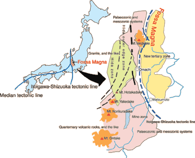
Japanese Islands later on. Along this border, Japan is divided into the
southwest Japan (Eurasia plate) consisting of the ancient strata/rocks
(the granite in the palaeozonic/mesozonic systems and the old tertiary
zone) and the Fossa Magna area (North American plate) consisting of the
new strata (the sedimentary rock and volcanic rock in the new tertiary
zone). The sediment extends over some 10km along Fossa Magna, which is
a factor contributing to the sediment-related disaster, too. The edge on
the west side of Fossa Magna is a group of faults called the gItoigawa-Shizuoka
Tectonic Lineh that runs the length of Japan from north to south. The
Itoigawa-Shizuoka tectonic line runs almost along the Himekawa River.
|
 |
|
  |
 |
| The earth that breathes - the North Alps |
| PDF version (2.4MB) |
|

