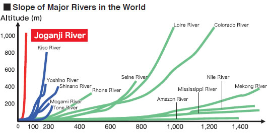
The Joganji River is only 56 km from the source to the river mouth Toyama bay. However, the altitude difference is about 3,000 m, and it is a torrent river with the world's leading gradient.
In the Toyama Plain where the Joganji River flows, the floods have frequently occurred from ancient times and threatened people's lives.
Characteristics of Joganji River
Distance from the Mouth of the River(km)
Even though its length is as short as 56 km (18 km in the plain section) for a Class 1 river, its average river bed gradient is as steep as 1:30 due to the huge elevation drop of some 3,000m between its source and the river mouth. The resulting rapid stream scours the ground in the upper reaches and transports a huge amount of sediment to the lower reaches.
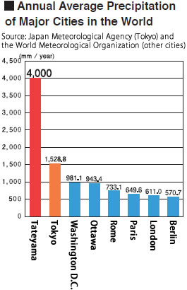
Japan is known to receive higher precipitation among developed countries. Joganji River Catchment Area receives an annual precipitation of about 4,000 mm, which is even higher than the national average (about 1,700 mm). With the maximum snow depth at the midstream of Joganji River reaching about 2.5 m (about 4.5 m in Mizutanidaira), the area is considered to be one of the heaviest rainfall/snowfall areas in the world.
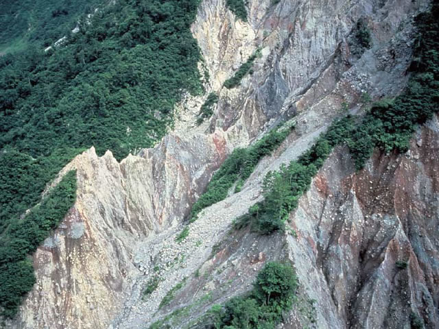
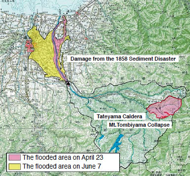
A collapse inside of Tateyama Caldera continually discharges sediment.
A huge amount of sediment called Tombidoro mud has accumulated in the Tateyama Caldera area due to the collapse of Mt.Tombiyama following a great earthquake in 1858 and other occasions. The amount of sediment which remains today is said to be as much as 200 million m3.
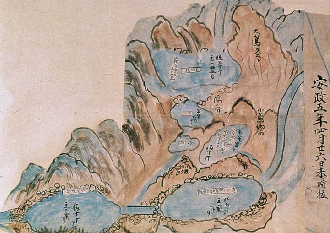
Mt.Tombiyama Collapse and 2 Times of Massive Debris Flow (1858)
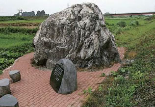
400 t of massive rock washed out to Toyama Plain by the 1858 Debris Flow
On February 26th (April 9th on the Gregorian Calendar), 1858, a great earthquake with an estimated magnitude of around 7 struck the Hietsu Region. This earthquake with a shallow epicenter right below the region was caused by the active Atozugawa Fault running to the west of the Tateyama mountain range. The earthquake caused numerous collapses of the inner slopes of the Tateyama Caldera at Mt.Ohtombi, Mt.Kotombi and other sites,blocking the flow of Magawa river and Yukawa river creating landslide dams.
The Occurrence of Debris Flow
On April 23, 14 days after the earthquake, another earthquake collapsed the sediment which had held back the flow of the river, resulting in a flush of the water held at the upstream to the downstream. The debris flow with massive rocks damaged the houses and hospice in Iwakuraji, the village in the middlestream of the Joganji River.
On June 7, the second large-scale debris flow hit the downstream of the Joganji River and destroyed the bank at a stretch, surging into the Toyama Plains. The Toyama domain where the Joganji River flows was evacuating beforehand in an effort to minimize the damage. In the records of the Kaga domain where was adjacent to the Toyama domain, it is recorded that there were even 140 people dead, 8,945 injured, many houses were damaged.
Creation of a Raised Bed River
A raised bed river refers to a river whose bed became higher than the surrounding land due to the accumulation of sediment inside a embankment.
After years of a large volume of sediment discharge, the Joganji River became a raised bed river. For this reason, once flooded, the river cannot hold back water and may cause a devastating disaster.
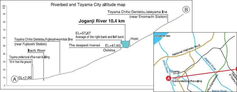
Cross-section of A-B which are shown in the figure to the right.