 |
|||||||||||||
|
|||||||||||||
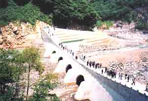
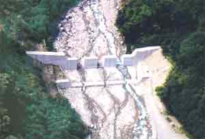
Sabo allowing sediment flow out There are a large number of steep rivers with shorter channel in Matsumoto Sabo control jurisdiction, with volcanic areas and devastated mountains typical of the North Japan Alps extending upstream. A large amount of sediment outflow in these steep rivers makes river courses unstable and sediment-related disasters serious. In the normal condition, allowing sediment to flow downstream is necessary for stabilizing the river course, maintaining the function of various facilities, reducing impacts on the ecosystem and preservation of coastal areas. In this respect, comprehensive sediment control is required in view of the consistency of the whole river-system covering the whole water flow from the mountains toward the coast. In the comprehensive river-system control, strategy for sediment movements should not be addressed at separate river areas like a water source, alluvial fan, river mouth and the coast, but comprise these whole river areas. Along Himekawa River, sediment movements are monitored not only in the Sabo control jurisdiction under the Sabo project but also in the whole areas from stream source toward the river mouth in cooperation with the river management division. Images in monitoring cameras are transmitted through optical cables to monitor drifting sediment and suspended sediment for realization of comprehensive sediment control. Furthermore, attempts have been made to develop Sabo dams which hold back sediment in floods and allow it to flow down in normal time. |
|||||||||||||
|
|||||||||||||