 |
 |
 |
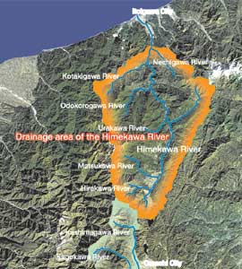
Drainage area of the Himekawa River
Length of river channel: 46km
Catchment area: 691.2km2
(upper stream of Yamamoto bridge)
Average bed slope: 1/16 |
| Alluvial fan developed because of many rapids and branches |
The Himekawa River has its source in the southern part of Hakuba Village.
Gathering many small branches together, it runs from the northern part
of Nagano prefecture through the southern part of Niigata prefecture all
the way to the Japan Sea. The upper reaches of the river are the steep
mountain area. The branches with heavy sediment discharge form a lot of
alluvial fans. In the middle reaches, Mt. Hieda that is the site of great
collapse discharges a large quantity of sedient. The Himekawa River that
runs almost along the "Itoigawa-Shizuoka tectonic line" is one
of the fastest flowing rapids in Japan with incessant occurrence of disasters.
|
 |
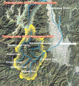
Drainage area of the Takasegawa River
Length of river channel: 31km
Catchment area: 350km2
(upper stream of Takase bridge)
Average bed slope: 1/13 |
| Nature of the rock vulnerable to weathering and steep slope |
The drainage area of the Takasegawa River is made up of three drainage
areas including the Honkawa River that flows out of Mt. Yarigadake plus
two other branches. The geological features in the drainage area are mostly
the granite that is vulnerable to weathering. Moreover, the forests are
hard to grow on the mountain ridge in the upper reaches of the river, and
the rocks are exposed. For this reason, the shallow landslide and the torrent
erosion are in progress. Weathering through the action of a hot spring
is added to this, and the sediment is discharged repeatedly during every
rainfall accompanied by the steep slope of the canyon, which often causes
a disaster.
|
 |
Drainage area of the Azusagawa River
Length of river channel: 50km
Catchment area: 559km2
(upper stream of Shinbuchi bridge)
Average bed slope: 1/20 |
| Sediment accumulation in the devastated upper reaches |
| Five branches join the Azusagawa River that has its source in Mt. Yarigadake.
The mountainous region in the upper reaches is extremely devastated by
the volcanic eruption and through the action of a hot spring, etc., and
a large quantity of sediment is accumulated there. The ejecta from Mt.
Yarigadake have often flowed down the slope as debris flow. Besides, the
granite in the drainage area has weathered considerably, which makes the
area vulnerable to a disaster when coupled with the lay of the land where
many small-scale valleys develop. |
| PDF version (1.0MB) |
|