History of the Land of Gifu Prefecture
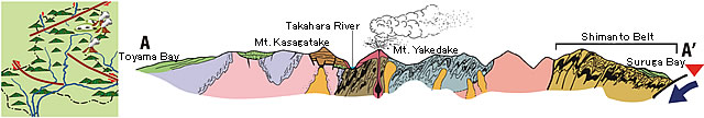
The geology of Gifu prefecture consists of various kinds of rocks and strata including rocks formed over 200 million years ago and deposits currently being formed because of the still ongoing movements of plates. Let's see major events around today's Gifu prefecture with illustrations and sectional diagrams. Since there are still things not known in detail, please be understood that the illustrations and sectional diagrams contain assumed data.Fig.1 Outline of geology of Gifu prefecture
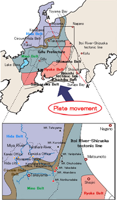
(Source: 1/2000,000 geologic province, Geological Survey of Japan)
About 500 million years ago
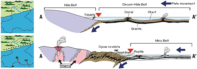
The northern part of today's Gifu prefecture corresponded to the eastern end of the then continent. The movement of the plate caused cherts, or sedimentary rocks composed of animal shells and bones, deposited on the southern sea bottom, limestone, or granite formed by eruption of submarine volcanoes, to be added to the land of the continental side one after another. The land then gradually expanded. It is presumed that the pushing pressure of the plate caused generation of magma inside the continental land and that volcanic activity also occurred.
About 200 million years ago
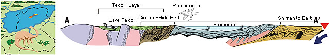
Part of the expanded land caved in to form a lake, Lake Tedori, and many kinds of animals including dinosaurs and plants prospered. The soil layers deposited on the bottom of Lake Tedori are known as Tedori Layer famous for its discovery of fossils including those of dinosaurs.
About 100 million years ago
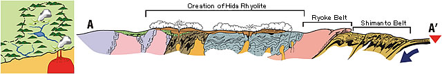
Fierce volcanic activity repeatedly occurred over wide areas ranging from the Tono area to Hida area, and volcanic ejecta thickly deposited to form the rhyolitic welded tuff. In this neighborhood, Mt. Kasagatake was one that actively erupted in those days.
About 10 million years ago
The push of the plate continues to eventually start upheaval of the Hida Mountains. Mountains, such as Mt. Dainichidake, continued volcanic activity. Mt. Dainichidake gradually ceased to erupt. New volcanoes emerged, which include those volcanoes still active today, such as Mt. Yakedake, Mt. Norikuradake, and Mt. Ontake.
Source of the sectional figures: Denrei Kanmera and Mitsuo Hashimoto, Jiryo Matsuda, Geology of Japan, p325-345, Earth Science 15, Iwanami
Earth Watching in Gifu, edited by the Gifu Prefecture High School Earth Science Education Research Association, Gifu Shimbun and Gifu Broadcasting, p106-109