High mountains, towering at over 3,000 m
A harsh environment where trees cannot grow
Mountains crumbling in heavy winds and rain
Giant rocks rolling downstream
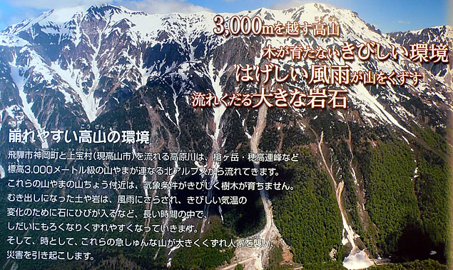
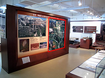
The Environment of High mountains, Prone to Crumble
The Takahara River that flows into Kamioka town, Hida city and the Kamitakara village (currently part of Takayama city) originates in the North Alps, which are composed of several mountains of over 3,000 meter high, such as Mt. Yarigatake and the Hodaka Mountains.
The top areas of these mountains have climatic conditions too severe for trees to grow.
Exposed soil and rocks are weathered by wind and rain and cracked by drastic temperature changes. Exposed to these conditions, they gradually become very likely to crumble and fall.
Eventually, large-scale landslides fall from these steep mountains, crushing houses and causing serious damage.
Miya River Disaster
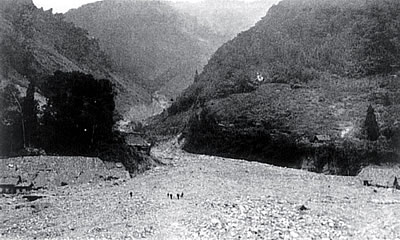
A large-scale sediment disaster occurred in Sakashimo village (currently part of Hida city) on August 13, 1914. A large volume of sediment dammed the Miya River, sending the river water back upstream. It was reported that the area just looked like a lake.
Horadani Disaster
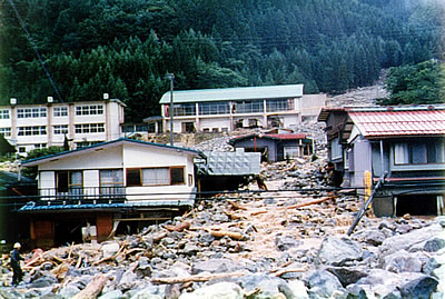
Debris flow occurred in the Tochio area on August 22, 1979.
This debris flow hit the community instantaneously, destroying 52 houses and two bridges.
Volcanic Eruptions Repeated over Centuries
Soil of volcanic ash likely to run down
Fragile and crumbly lava
Heavy rain pushing crumbled rocks
Volcanic sediment is fragile and flows down easily
The Hida Mountain Chain include volcanoes such as Mt. Yakedake and the Norikura Mountains which have erupted many times over the centuries. Erupted lava and fallen volcanic ash are deposited in layers. This sediment is so fragile that is washed away little by little with every rainfall.
When heavy rains come, the surface of steep slopes and volcanic ash run down as debris flow.
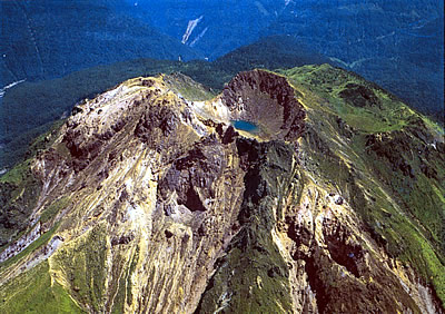
Top of the present Mt. Yakedake
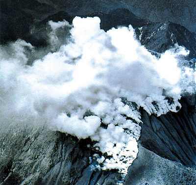
Eruption in 1962
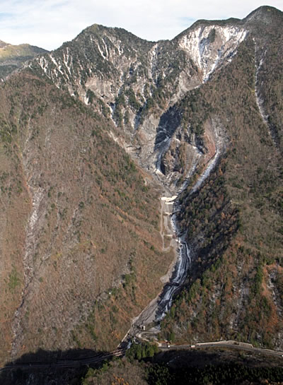
Collapse of Shiratani
Even today debris flows occur every year.
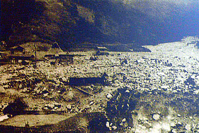
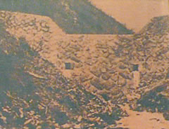
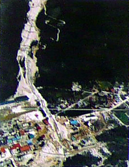
Miya River Flood Damage
(Damage to Sakashimo Village)
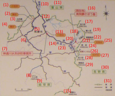
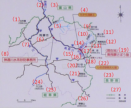
Origins of the Jinzu Sabo(1910 - 1920)
The History of the National Government's Erosion Control Dates Back 100 Years
Flood disasters occurred at various parts of the country in 1910, and serious damage was also done in the Jinzu River basin. These disasters led to the national government's decision to start erosion control (sabo) works in 1911. The Jinzu River was selected as one of the rivers where sabo works were to be conducted. In August 1914, an unprecedented flood occurred. Devastating debris flow hit Sakashimo village (currently part of Hida city) and caused disastrous damage to the village including the loss of 36 people's lives. Sediment ran downstream and was deposited in the river. It raised the riverbed and made the river more likely to flood. The sediment that ran downstream also raised the depth of the water at the Toyama Port and rendered the port almost unable to maintain its port functions. A large-scale sabo project was then necessary in the upstream reaches of the Jinzu River to prevent such a situation. In 1919, the national government decided to conduct the work, and the Sakashimo Sabo Plant was set up as a field organ under the Niigata Construction Branch Office of the Home Ministry.Heavy rain pushing crumbled rocks downstream.
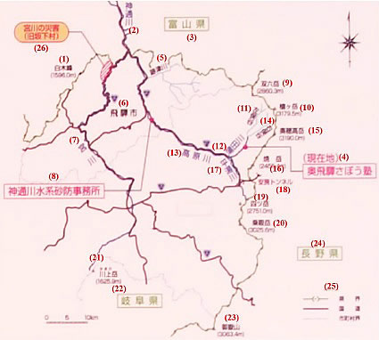
- Mt. Shirakimine
- Jinzu River
- Toyama Prefecture
- (Current location)
Okuhida Sabo Juku - Atotsu River
- Hida City
- Miya River
- Jinzu River Sabo Office
- Mt. Sugorokudake
- Mt. Yarigatake
- Hidarimatadani
- Gamada River
- Takahara River
- Migimatadani
- Mt. Okuhodakadake
- Mt. Yakedake
- Hirayu River
- Abo Tunnel
- Mt. Yotsudake
- Mt. Norikuradake
- Mt. Kaoredake
- Gifu Prefecture
- Mt. Ontake
- Nagano Prefecture
-
- Prefectural border
- National highway
- Municipal border
- Miya River Flood Damage
(former Sakashimo village)
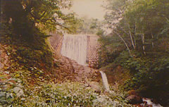
Stone masonry sabo dam
(Iwatsubodani No.1 Sabo Dam)
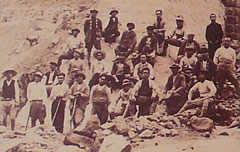
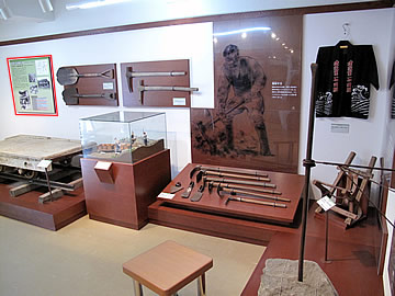
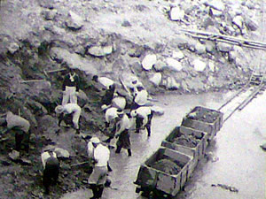
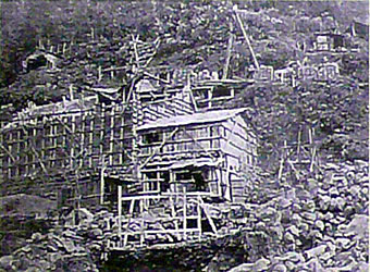
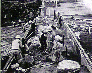
Workers in the Days When Work was Directly Conducted by the Home Ministry
Early Sabo Works(1921 - 1944)
The sabo works of 90 years ago were built by manual labor.
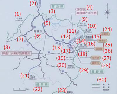
The sabo works in the upstream reaches of the Jinzu River were constucted by the national government from 1919 to 1931. Sabo works were constructed on the Miya River at Azukisawa, Kuwatani, and Takidani, and on the Takahara River at Rokurodani.
The village of Kamitakara (currently part of Takayama city), Gifu Prefecture, made a petition in 1929, and the municipalities in Yoshiki-gun, Gifu Prefecture, jointly submitted a petition to implement sabo works projects in the upstream area of the Jinzu River in 1930. In the same year, 1930, the Governor of Toyama Prefecture submitted an opinion to apply for national treasury disbursement to implement sabo projects for the Jinzu River. In response, work started on the Gamada River at Ashiaraidani and on the Hirayu River at Iwatsubodani in 1932.
In those days, although construction machinery had been introduced, the majority of work was done by manual labor. It was manual labor that cut out roads to transport materials, and quarried and carried the stone to use as materials. Sabo dams in those days were constructed by stone masonry, by breaking up large rocks into rocks of about 1m in diameter and then stacking them up.
-
Takigawadani No.1 Sabo Dam -
Rokurodani hillside works
- Azusawa
- Takidani
- Mt. Shirakimine
- Kuwatani
- Hida City
- Miya River
- Jinzu River Sabo Office
- Mt. Kaoredake
- Gifu Prefecture
- Jinzu River
- Toyama Prefecture
- Atotsu River
- Rokurodani
- Takahara River
- Mt. Ontake
- Okuhida Sabo Juku(Present site)
- Mt. Sugorokudake
- Hidarimatadani
- Mt. Yarigatake
- Gamada River
- Migimatadani
- Mt. Okuhodakadake
- Hirayu River
- Mt. Yakedake
- Ashiaraidani
- Abo Tunnel
- Iwatsubodani
- Mt. Yotsudake
- Mt. Norikuradake
- Nagano Prefecture
-
- Prefectural border
- National highway
- Municipal border
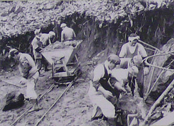
Sabo Works Get into Full Swing(1945 - 1969)
Small-sized Machines Came Into Use About 60 Years Ago.
Post-war sabo works on the Jinzu River began in 1949. The first facility constructed was the Hikage No. 1 Sabo Dam. In 1952, the Kamisaka Sabo Dam was damaged by a flood. Furthermore, a large-scale landslide occurred on the mountain side on the left bank side in the upstream reaches of the Sodegadani stream. The risk of large amount of sediments flowing down increased, and the sabo plan was revised.
In 1954, the Jinzu River System Sabo Work Office (currently Jinzu River Sabo Office) was set up to cope with the increasing number of sabo projects. The sabo works were expanded to the main channel of the Gamada River, the Ashiaraidani stream, the Sodegadani stream, the Konabedani stream, the main channel of the Hirayu River, the Iwatsubodani stream, and the Esakakedani stream.
Before the middle of the 1950s, stone masonry was the mainstream method of sabo dam construction. This method was replaced by concrete construction and small machines were actively introduced into sabo works.
- Mt. Shirakimine
- Jinzu River
- Toyama Prefecture
- Okuhida Sabo Juku(Present site)
- Atotsu River
- Hida City
- Miya River
- Jinzu River Sabo Office
- Mt. Sugorokudake
- Mt. Yarigatake
- Hidarimatadani
- Gamada River
- Takahara River
- Migimatadani
- Mt. Okuhodakadake
- Mt. Yakedake
- Hirayu River
- Abo Tunnel
- Mt. Yotsudake
- Mt. Norikuradake
- Mt. Kaoredake
- Gifu Prefecture
- Mt. Ontake
- Konabedani
- Sodegadani
- Ashiaraidani
- Iwatsubodani
- Esakakedani
- Nagano Prefecture
-
- Prefectural border
- National highway
- Municipal border
-
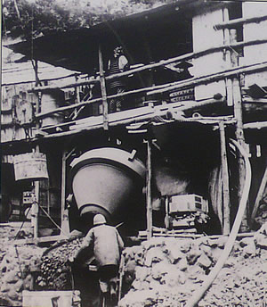
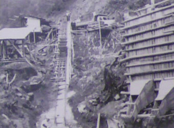
Concrete plant -
Hako torokko (box-shaped trolley)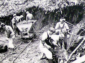
Nabe torokko (pan-shaped trolley) -
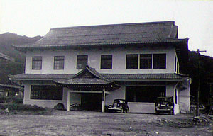
Jinzu River System Sabo Work Office in 1954
Bringing Back Rich Greenery to Barren Land - Sabo to Protect People's Livelihoods in Okuhida
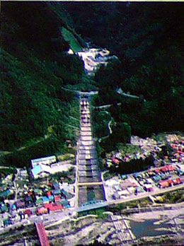
Greenery Restored to Rokurodani
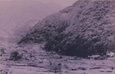
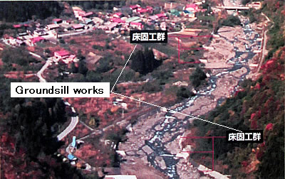
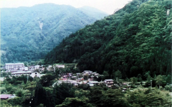
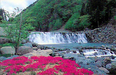
Rokurodani is a small stream in front of the Kamioka Kozan Station. Gold and silver were mined in the hillside of Rokurodani in the Edo Period. Water used to clean ores was discharged into the Rokurodani stream, which eventually made the stream dirty and barren. In 1872, a large landslide occurred in Rokurodani. In 1899, heavy rainfall caused sediment run off to dam the Takahara River. Hida city (formerly Kamioka town) was often damaged by such disasters. As a solution, sabo works were finally conducted from 1920 to 1930, including construction of sabo dams, ground sill works, and hillside works. As a result, the valley was stabilized, and a zinc refinery was constructed in the alluvial plain part. The greenery of the past is now restored to Rokurodani.
-
Barren land devoid of greenery -
Sabo works conducted in the early days of Showa Era
Sediment run-off completely stopped and greenery has been restored to Rokurodani valley.
Greenery Created at Fukuji
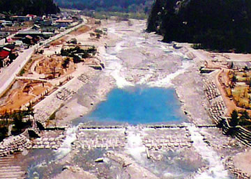
Typhoon No.11 that hit the Okuhida area from July 25 to 26 in 1958 caused debris flows as high as 20m, temporarily stopping the flow of the Hirayu River.
The impounded water was finally breached but the riverbed rose by about 3m. It completely changed the look of the river. Construction of sabo facilities including sabo dams, groundsill works, and revetment works was completed in 1960 after about 25 years' work. A rich green environment was created at the Fukuji Hot Spa area under the protection of these facilities. Today the hot spa enjoys prosperity as a hot spring community that features a sedate mountain village environment.
-
Fukuji in the 1950s -
Sabo works were conducted (from the 1960s to 1980s)
Sediment is stabilized and greenery is restored to Fukuji.
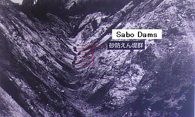
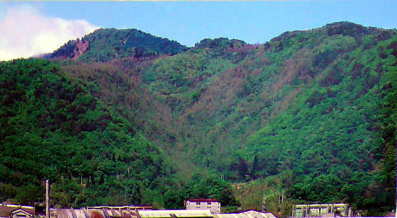
Restoration after the Horadani Disaster
Horadani is a mountain stream that flows through the Tochio Hot Spa community (Okuhida Hot Spa Resort, Takayama city; formerly Kamitakara village).
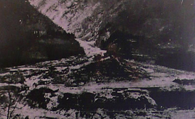
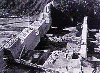
Record-breaking heavy rainfall with an hourly rainfall of 83 mm occurred in Okuhida area due to Typhoon No. 11 that hit the area from August 21 to 22, 1979. Debris flow was triggered by a landslide in the headwaters upstream of Horadani at around 7:50 on August 22. Large amounts of sediment including gigantic rocks instaneously hit the Tochio Hot Spa community. The debris flow washed away bridges, destroyed a junior high school, covered the roads with an 8m-thick layer of sediment, and buried buildings. The victims included two persons killed, one person missing, and 52 houses destroyed.
Buildings buried under the debris flow(1979)

Shigeo Kashiwagi's Story(resident of Tochio)
The rain was so heavy we could not run away although we desperately wanted to.
Water dashed into the first floor of my house up to a level of 1m. We could do nothing but stay put. But fortunately the water began to recede. Whenever a disaster occurs, I strongly feel what is important is the power of many people helping each other. I really thank all those who helped me. I am so happy and thankful that a very good revetment has now been constructed.
Horadani area, where the townscape was restored as a result of the completion of sabo facilities.

Chieko Kamiki's Story(resident of Tochio)
If I remember correctly, it was about 7:40 in the morning. When I was preparing breakfast for our guests, I heard a roaring sound just like a big earthquake. I hurriedly went upstairs to wake up the guests. When I looked outside, I saw electric poles being washed away. We just barely escaped, by going barefoot. When we got outside, we saw the sediment was almost upon us just like a great sea. I was so terrified. The sediment crushed our house but fortunately we saved the lives of our guests.
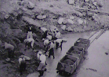
How Sabo Dams Were Constructed
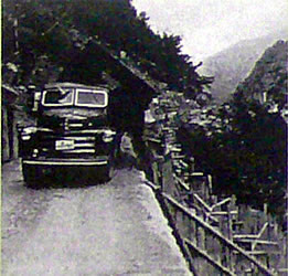
Compact four-wheeled trucks came into use in sabo dam construction from around 1950, after the Nakao Bridge, which was originally a suspension bridge, was reconstructed as a wooden bridge and a service road for transporting construction materials was built.
After around the middle of the 1950s, machines were introduced, and laborers and machines began to work simultaneously at construction sites.
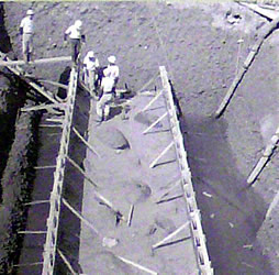
The panoramic model on display is a reproduction of a construction site of the Sodegadani No. 3 Sabo Dam in around the middle of the 1950s based on extant drawings, photos, and interviews with the people who worked there.
In this model, we can see trucks transporting construction materials, a concrete plant producing concrete, workers using machines such as concrete placement with vibrators, at the same time as manual labor using rucksacks and sleighs.
-
Kaishio Sabo Dam work -
Stockyard plant -
Concrete placement -
Concrete placement (vibrator)
-
From truck to stockyard -
Concrete plant -
Nabe torokko
(pan-shaped trolley) -
Hako torokko
(box-shaped trolley)
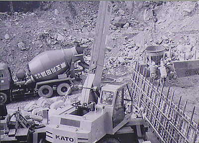
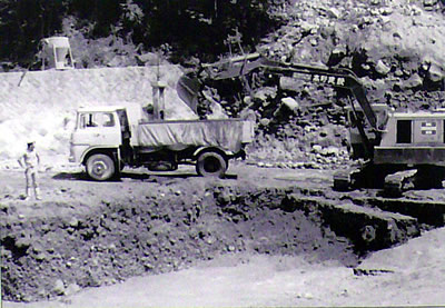
Sabo Works Using Large Machines(1970 to the Present Day)
Forty years ago, great changes occurred at construction sites due to advances in erosion control technology.
A permanent ready-mixed concrete plant was set up at two locations in Kamitakara village (currently part of Takayama city) from 1969 to 1970. Before that, a concrete plant was set up at each sabo work site. This work, however, was eliminated when the permanent concrete plants were constructed and greatly changed construction sites.
On the other hand, as construction roads developed, it became possible to transport large civil engineering machines directly to work sites. Truck cranes began to be used for concrete placement. Backhoes designed to excavate sediments with large shovels came into use for excavation. This greatly enhanced work efficiency, speeding up construction of sabo works.
Sabo dam construction with large machines
-
Backhoe loading sediments on a truck -
Truck and concrete mixing car
Sabo Projects Conducted in Unity with the Local Community
1992 to the Present Day
Today, the opinions of local residents are incorporated into implementation of sabo projects.
Kamitakara village (currently part of Takayama city) announced its "Sabo Learning Village Declaration" in 1997. The project implementer and local community work together and discuss with each other to realize appropriate erosion control as part of overall local development work. In this joint effort, the sabo project itself is also used as an opportunity for people to learn about sabo works.
Sabo facilities are constructed in a manner that is friendly to the environment, local tourism, and society so that they have less impact on the natural environment and look harmonious in a tourist setting.
- Mt. Shirakimine
- Jinzu River
- Toyama Prefecture
- Takara Channel Works
- Atotsu River
- Hida City
- Miya River
- Jinzu River Sabo Office
- Mt. Sugorokudake
- Hidarimatadani
- Mt. Yarigatake
- Mt. Okuhodakadake
- Migimatadani
- Gamada River
- Takahara River
- Hirayu River
- Mt. Yakedake
- Abo Tunnel
- Okuhida Sabo Juku(Present site)
- Mt. Yotsudake
- Mt. Norikuradake
- Shinobu Sabo Dam
- Nagano Prefecture
- Mt. Kaoredake
- Gifu Prefecture
- Mt. Ontake
-
- Prefectural border
- National highway
- Municipal border
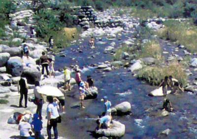
Takara Channel Works where people can enjoy the water environment
Shinobu Sabo Dam
Shinobu Sabo Dam as a field classroom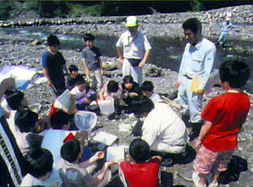
Takara Channel Works