
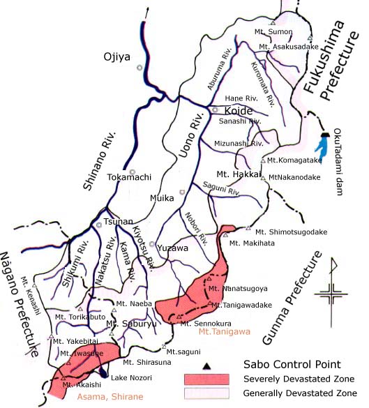
Headwater areas under the jurisdiction of the Yuzawa Sabo Works Office consist of devastated mountain land which is divided into the Mt. Tanigawadake severely devastated zone, centering on the Tanigawa mountain range, the Asama-Shirane severely devastated zone around Mt. Asama and the Tadami-Nikko-Joshin'Etsu generally devastated zone which covers most of the headwater mountain land under the jurisdiction of the Office. Such volcanoes as Mt. Iiji, Mt. Asakusadake, Mt. Sumondake, Mt. Naeba, Mt. Torikabuto and Mt. Yakebitai dot the area and extremely fragile volcanic eject from these volcanoes constitutes some 10% of the ground materials. In addition to the general state of devastation, heavy snowfall of some 3 - 5 m deep causes frequent sediment outflows by avalanches and melted snow.
The proximity of housing sites to headwater areas makes them liable to damage by sediment disasters. The necessity to implement sabo projects throughout the area has become more urgent because of not only the development of the area as a ski resort, making the best use of its geographical proximity to large urban areas, but also because of vigorous local development activities, including the Oku-Tadami Recreation Zone Development Project which commenced in 1985 in and around the North Uonuma District and approval of the basic concept of the My Life Resort Niigata Project in fiscal 1987, formulated following the enforcement of the Integrated Resort Area Development Law.
The implementation of sabo projects in the area is required to pay special attention to the presence of national forests widely covering headwater areas and also to the presence of the Joshin-Etsu Kogen Quasi-National Park around Mt. Naeba, the Echigo Snazzy-Tadami Quasi-National Park around Mt. Komagadake, Mt. Nakanodake and Mt. Hakkai and the Uonuma Mountain Range Prefectural Natural Park around Mt. Makihata.
| River | Trunk River | Drainage Area (km2) | Total Channel Length (km) | Mean Channel Profile | Typical Rocks | Headwater Area |
| Uono | 1,503.6 | 68.4 | 1/49 | Å@ | Mt.Tanigawadake (El. 1,963 m) |
|
| Aburuma | 509.3 | 46.0 | 1/39 | Andesite | Mt. Sumondake(El. 1,937 m) | |
| Sanashi | 88.4 | 21.7 | 1/38 | Granite | Mt. Komagatake(El. 2,003 m) | |
| Mizunashi | 50.2 | 19.1 | 1/19 | Phyllite | Mt. Nakanodake(El. 2,085 m) | |
| Saguri | 153.4 | 23.3 | 1/20 | Gabbro | Mt. Shimotsugodake(El. 1,928 m) | |
| Nobori | 83.2 | 18.5 | 1/16 | Granite | Mt. Asahidake(El. 1,945 m) | |
| Daigenta | 45.8 | 9.7 | 1/12 | Granite | Mt. Daigenta(El. 1,597 m) | |
| Upper Reaches of Uono | 93.2 | 15.0 | 1/21 | Granite | Mt. Tanigawadake(El. 1,963 m) | |
| Remaining Areas | 480.1 | Å@ | Å@ | Å@ | Å@ | |
| Kiyotsu | Å@ | 307.4 | 44.0 | 1/32 | Quartz Diorite | Mt. Shirasuna(El. 2,139 m) |
| Nakatsu | Å@ | 345.9 | 45.8 | 1/27 | Andesite | Mt. Iwasuge(El. 2,295 m) |
| Shikumi | Å@ | 118.3 | 17.4 | 1/14 | Andesite | Mt. Torikabuto (El. 2,038 m) |
Uono River |
Uono River has a drainage area of 1,504 km2, a total channel length of 68 km and a mean channel profile of 1 in 49. Its drainage area accounts for some three-quarters of the area managed by the Office. It is the largest tributary in the middle reaches of Shinano River and its own tributaries include Imokawa, Aburuma, Sanashi, Mizunashi, Saguri, Nobori and Daigenta, all of which are right bank tributaries. A large fan has developed around the confluence points. The 2,000 m class mountain range forming the headwater area shows steep, complicated topography. Vigorous weathering and erosional activities have created a sharp ridgeline and many small valleys have developed on the hillsides, particularly in the granite-dominated area. The upper reaches of Aburuma River consist of metamorphic rocks and gabbro originating from Sumon volcanic ejects of the Quaternary Period. Sabo works directly controlled by the Ministry of Construction have been implemented to contain the high level of sediment outflow from the highly fractured drainage areas of Mizunashi River and Saguri River and the weathered granite areas in the lower reaches of Aburuma River, drainage areas of Sanashi River, Nobori River and Daigenta River and the upper reaches of Uono River. The main channel of Uono River is accompanied by such transport arteries of the Hokuriku Region as National Route 17, JR Joetsu Line, Kan-Etsu Motorway and Joetsu Shinkansen. The subject drainage areas and their surrounding areas are endowed with rich tourist resources, offering many ski resorts and other recreational sites. Intense development of the area is in progress, including the Oku-Tadami Recreation Zone Development Project and other major projects. |
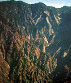 Collapsed area in the upper reaches of Mizunashi River (western slope of Mt. Nakanodake) |
Kiyotsu River |
Kiyotsu River has a drainage area of 307 km2, a total channel length of 44 km and a mean channel profile of 1 in 32, running northwards. Its tributaries include Asakai River and Futai River, right bank tributaries in the upper reaches, and Kama River, a left bank tributary in the lower reaches. The drainage area has its water source at Mt. Naeba (El. 2,145 m) and is covered by volcanic eject of the Quaternary Period. Many severe landslides and erosion are witnessed in the upper reaches where virgin forests of buna (Fagus crenata) are widely distributed. Deep valleys creeping up near the ridgeline characterize the drainage area but the topography generally shows the stage of maturity. A V-shaped valley called "Kiyotsu Valley", which is designated a natural monument of scenic beauty, lies in the middle reaches. The character of the sphere of life differs between the upper reaches and lower reaches with Kiyotsu Valley forming the dividing area. The upper reaches belong to the sphere of life of the Uono River drainage area, providing a recreation area around the Naeba ski resort. |
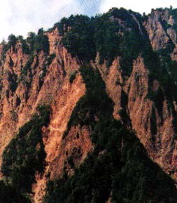 Collapsed area in the uppermost reaches of Kiyotsu River (eastern slope of Mt. Shirasuna) |
Nakatsu River |
Nakatsu River has a drainage area of 346 km2, a total channel length of 46 km and a mean channel profile of 1 in 27, running northwards in parallel with Kiyotsu River. While its upper and lower reaches are located in Niigata Prefecture, Senzawa, one of its tributaries, originates from Lake Nozori in Gunma Prefecture. Mt. Eboshidake, Mt. Torikabuto and other high mountains form very steep topography with exposed bedrock. The drainage area is covered with volcanic eject of the Quaternary Period and valleys, created by erosion of the volcanic body and accompanied by giant Collapsed areas, have developed on the western slope of Mt. Naeba in particular, producing the most severely devastated land. Settlements are scattered in the middle and upper reaches, forming an area called Akiyama County, which was once a hiding place for fugitives of the Heike Clan. Hot springs are also dotted in this area. The lower reaches form terraced topography and the wide channel is a source of sediment outflow due to the secondary erosion of deposited unstable sediment |
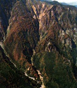 Collapsed area in upper reaches of Nakatsu River (Shirasawa Valley deeply cutting the eastern slope of Mt. Torikabuto) |
 |