Plate Activity
Continents Move

Alfred Wegener
(1880 - 1930)
A look at the world map shows that South America and Africa, which are located across the Atlantic, look like they can be jointed together like jigsaw puzzles.
In the 1910s, German meteorologist Alfred Wegener hypothesized that a giant continent Pangaea, a collection of all of today's continents, existed about 200 million years ago based on his research on the geology related to where present and ancient extinct animals and plants lived, rocks, and signs of glaciers. He maintained that the "continents surely move".
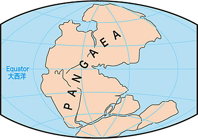 Fig.1 How the continents looked about 200 million years ago as proposed by Wegener
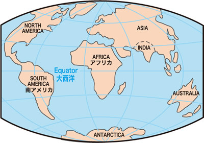 Fig.2 Present distribution of continents
A new sea bottom is born under the sea?
The continental drift theory of Wegener caused a big debate in the academic circle. In those days, the conventional wisdom was that "the continent or sea bottom never moves". In the 1980s, an epoch-making discovery that upset the conventional wisdom that "the continent or sea bottom never moves" was achieved from marine survey.
It was revealed that a new sea bottom is born at the marine mountain range called the Central Ridge and spreads on both sides.
Today, it is known that the subsurface of the Earth is covered by tens of hard rock layers called "plate". A plate is born at the Central Ridge, moves, and sinks under another plate at the ocean deep. As a result of these plate movements, the continent and sea bottom also move even now.
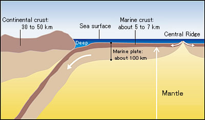 Fig.3 Schematic illustration of how a new sea bottom is born from the Central Ridge
Mantle Convection - Driving Force that Moves Continents
The driving force of plate drift is assumed to be the convection of the mantle inside the Earth.
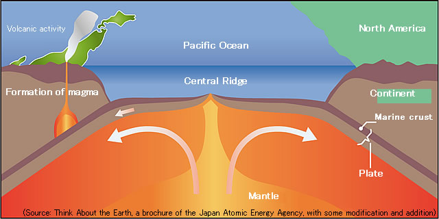
Fig.4 Schematic illustration of the mantle convection, the driving force of plate drift
Japanese archipelago and its vicinity where four plates are intensively located
Of the major plates covering the Earth today, four plates are located in a very crowded condition around the Japanese archipelago as shown in the right figure. The Philippine Sea Plate sinks under the Eurasian Plate, the Pacific Plate sinks under the North American Plate, and the Pacific Plate sinks under the Philippine Sea Plate.
As shown in this figure, the underground of a plate under which another plate sinks receives high pressure and generates magma. shown in the right figure indicates a major active volcano on and around the Japanese archipelago.
Japan having a lot of earthquakes and volcanoes is greatly connected to concentration of plates.
The text and figures (excluding the data directly used on the figures): Article of "Research Frontline Leading from Science Subject, History of Continental Drift - Mantle Convection - Earth", Blue Earth, 2011, combined issue of 1 and 2, No. 111th issue, p. 24-28, Japan Agency for Marine-Earth Science and Technology, with some text modification and addition
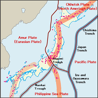
Fig.5 Location map of plates around the Japanese archipelago
(Prepared by the Sediment Disaster Prevention Publicity Center)